Level editor
The level editor is used to create custom maps in Unturned. It has been a publicly-available feature starting from the game's initial pre-release build.
From the main menu, players can create a the files necessary for their new custom map, and set some of the map's settings. Players may name their map, set the map's size, and specify the map's gamemode. Afterwards, they can select their newly-created map and begin editing. When a new map is created, its editability is locked to the map's creator. Editing tools can be selected from the top of the editor, with the tools being split across four top-level categories.
There also used to be support for editing while using virtual reality (VR) devices, but this support has since been removed from the game.
Terrain tools
The landscape of a map can be edited through the terrain toolset. The toolset allows for manipulating the level's geometry, terrain type, and resource spawns.
Heights
With the heights tool, players can manipulate the level's heightmaps. Unturned levels use two distinct heightmaps, with the main difference being in collision. The primary heightmap has collision and is meant to be used for all the terrain without the playable bounds of the map. Meanwhile, the secondary heightmap does not feature collision, and is meant to be used outside the playable map bounds. Additionally, details and resources will not automatically generate on the secondary heightmap when bake function. Both heightmaps support the terrain being raised, lowered, smoothed, and flattened; and both will be automatically textured when using the bake tool for materials.
Materials
Alphamaps are managed with the materials tool. With the level editor, a total of eight unique materials can be loaded for use on that map. To use more than eight materials, alphamaps must be managed from the devkit editor instead. Each alphamap material can be individually configured. These configurations affect how materials are automatically generated when using the bake function, and such as restricting the generation to a certain height or steepness. They also affect the details and resources that can automatically generate on the material when using those respective bake functions.
Details
Details are purely aesthetic, and are distributed across the map through the use of detailmaps. The level editor only supports ten different detail types, so the devkit must be used in order to add additional assets. The details made available by default are four flower assets, two grass assets, a wheat asset, and three pebble assets. The baking density and spawn chance can be configured per detail.
Resources
The resources tool allows for managing the level's resourcemaps. Resources can typically be mined, chopped, or otherwise harvested for items and experience. Any number of resources can be loaded into the level editor, and each resource can be individually configured to automatically generate under specific conditions when using the bake function. Resources can be baked locally, globally, or within the skybox. Local baking occurs near the player's current camera position, making it useful for only replacing a small area with the desired resources. Global bake will generate resources across all primary terrain, while the skybox bake will generate across all secondary terrain.
Environment tools
The environment tools are used to manage level ambience, pathfinding, and roads. Its toolset includes the lighting tool, roads tool, navigation tool, and nodes tool.
Lighting
The lighting tool, also called the day/night tool, allows for customizing and previewing the map's skybox, weather, and sea level. The right toolbar consists of settings for controlling the day/night cycle and other skybox elements, while the left toolbar mostly consists of weather-related settings.
Each map has an azimuth, bias, and fade. The azimuth determines which direction the sun (and moon) rise and fall across the map.
Bias—more accurately called day/night bias, or the day/night ratio—controls the length of the daytime and night. Moving the slider further to the right results in shorter nights. A bias of 0.25 would divide the map's day/night cycle into being 25% daytime, and 75% night. The shortest possible daytime length is 1 second, while the shortest possible night length is 0 seconds.
Fade affects the transition length between the four main parts of the day: dawn, midday, dusk, and midnight. Each part can have its lighting configured separately from the others. The transition length between each part can be up to 50% of the day or night – whichever is the shorter of the two, depending on the bias – based on the 0 to 1 fade value. Commands like /day and /night are affected by fade.
Lighting throughout the day can be previewed with the "Time" slider in the bottom-left corner. Note that when bias is 1, or fade is 0, lighting not exist at certain parts of the day.
Roads
The roads tool, or paver, is used to create roads. This is done by plotting multiple points across the map. Upon baking the road, it is generated using spline-based procedural geometry and will follow the points in the road network. There are multiple road textures that can be used when creating roads.
A navigation mesh (navmesh), is an abstract data structure used by artificial intelligence to aid in pathfinding. The navigation tool allows for creating these navmeshes. Navmeshes are used by zombies, which are otherwise unable to move when spawned outside a navmesh.
When a navmesh is placed on a map, it is marked in the level editor with a white flag. The flag turns red when selected. This flag marks the center of the navmesh, and by selecting the flag the properties of the navmesh can be tweaked.
Nodes
The nodes tool is used to create a variety of different ambience nodes. There are seven types of nodes: arena, deadzone, airdrop, effect, location, safezone, and purchase.
Spawns tools
Game spawns for items, animals, vehicles, and zombies are managed by the spawn tools. These tools allow for placing spawn points, configuring spawn properties, and adjusting spawn tables. However, it is not recommended to use the level editor to implement spawn tables for items, animals, or vehicles. Instead, spawn tables should be constructed within DAT files using the Spawn asset type, and then referenced in the editor through the Spawn ID field.
Level tools
The fourth toolset is the level toolset, also called the world tools. Level tools allow for placing objects and NPCs, toggling visibility for various in-editor elements, and managing player spawn points.
Objects
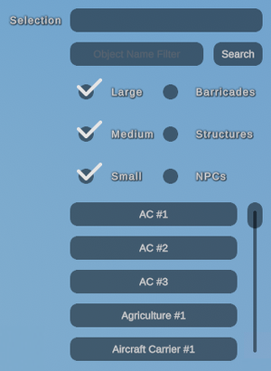
Objects are models that can be placed onto maps. They serve as props for players to loot, explore, and travel upon or through. They may be purely decorative with merely aesthetic value, or they can be interactable. NPCs are considered to be a type of interactable object, along with many quest objects. Objects pertaining to NPCs are often affected by external conditions that may influence when or how they appear, and as such are only seen client-side when it is appropriate for that individual player to see them. This makes such objects non-ideal for use outside of their intended functions. Traditionally player-made structures and barricades can be placed through the level editor as well, but these can be salvaged by any player who comes across them, permanently removing them from that location until the world's savedata is reset. There are multiple filters available to players when searching through the object list. When the desired object is selected, it can be spawned with E by default. Objects have three transformation options: translate, scale, and rotation. When holding Ctrl, objects can be snapped to a grid-like placement system, based on the specified snap distance.
Visibility
The visibility tab provides a simple list of toggles regarding the visible display of various in-editor elements. These settings have no effect on the level itself, and are only relevant while in the editor. While the visibility tab remains open, a numbered grid is rendered over the level, with each number representing coordinates. The function keys can be used to quickly toggle each individual setting on or off, without needing to navigate to the visibility tab.
Player
Player spawn points can be toggled between arena placements and normal spawn points. This is only relevant for the arena game mode, where players initially spawn in a lobby area during intermission periods and when they first join, but are teleported into the arena during gameplay.
Volumes
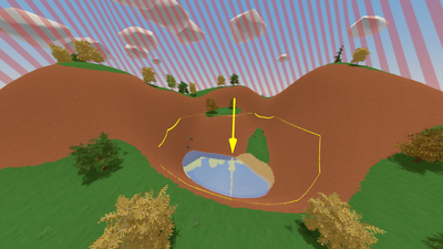
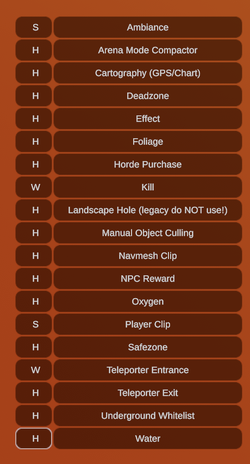
The Volumes tab provides a large list of different volumes the editor can choose to place in the world. Each row has two columns, a visibility column, which can be set to Hidden, Wireframe and Solid. Most volumes, with the notable exceptions of Effect and Cartography can be toggled from either a box or sphere shape. The aforementioned volumes can only be placed in the "Box" shape, in contrast, the Arena Mode Compactor volume can only be placed as a sphere.. The water volume can be toggled to a sphere, the surface is not rendered, regardless of what surface settings are set as. The Landscape Hole volume cannot be placed from the editor, it exists purely as a backwards compatibility step to auto paint holes in the terrain. While most volumes are straightforward, several have more nuances to them. Specific information can be found in the Modding sections.
UNLOCKER
Maps can be edited by someone other than the map's initial creator, provided that the map has been unlocked with an unnamed UNLOCKER file. The UNLOCKER file must be placed inside each individual map's folder, for those maps to be unlocked. If your file manager is configured to show file extensions at the end of file names, and allows for empty file names, then creation of an UNLOCKER is straightforward. Create a new file, and simply rename it to ![]()
.unlocker.
Alternatively, an unnamed UNLOCKER file can be created through a command-line interpreter.
Devkit
There used to be two level editors: the legacy editor, and the devkit. The devkit level editor was more technically advanced compared to its predecessor. It included a number of new features and quality-of-life improvements, but it was generally regarded as being much more difficult to use. Additionally, some tasks would still require using the legacy level editor.
The devkit started being deprecated in the 2022 year, and was ultimately removed. By the time the devkit was removed, most of its unique features had since been merged into the legacy editor.
Update history
- Fixed base of street light object being red.
- Increased width of filing cabinet object.
- Fixed a copy-paste bug in the editor.
- Added parking line model for designing parking lots.
- Resource placement when baking is now affected by material chance and overgrowth.
- Resources are saved with a higher-priority position which fixes a tree position bug.
- Added new tree and bush models.
- Added new rocks and flowers.
- Improved tree rotation distinction.
- Changed height/steepness to sliders.
- Raised max level height due to popular demand.
- Fixed details appearing under the ocean.
- Improved flatten tool to use a height slider.
- Use E to sample height with the flatten tool.
- Decreased max level height.
- Fixed several UI issues caused by clearing maps.
- Fixed resource baking putting resources inside buildings.
- Fixed collision of store cooler objects.
- Added default settings to new maps.
- Added random scaling to resources.
- Temporarily disabled water.
- Added an all-new brush system to allow painting/terraforming along the edges of the map.
- Added a Detective Riley billboard object.
- Place basic spawn points in the level editor.
- Level editor supports eight ground materials (two splatmaps) at a time, with 4× resolution, as well as the ability to mark which materials have grass and rock details.
- Modify the day-night cycle with the level editor.
- Road tool in the level editor, with different road textures.
- Build loot tables in the level editor.
- Tools in the level editor for texture painting, copy/pasting objects, and adjusting sun color.
- Many new objects for use from the level editor, and higher-fidelity assets compared to Unturned (classic).


